Saturday, July 29, 2006

Ryde Pier at Night

One of my personal favorite pictures I`ve shot of Ryde Pier. The reflections came out well and with the added touch of cloud and the car headlight trails it has that nice sparkle. I hope you enjoy this picture as much as I enjoyed taking it!

Friday, July 28, 2006

Ryde at Night

A little bit of digital trickery with the car lights gives the scene a ghostly appearance ;)

Location: At the bottom of Rydes main shopping street.

Thursday, July 27, 2006

Mystery Plant

While out wandering one day I came across these strange plants. I have no idea what they are but they looked fairly dramatic. Answers on a postcard please!

Wednesday, July 26, 2006

Trees

Trees before summer arrived.

Tuesday, July 25, 2006

Old Rope

As Ryde is a seafaring town I thought I`d post a picture of some rope that I found in the yacht marina.

Monday, July 24, 2006

Paddling Pool

Couldn't resist posting this picture - I love reflections ;) This is the paddling pool at the far end of Ryde Seafront. This shot was taken in the winter after a storm which is why theres no children here, the waterfall isn't running and the trees have no leaves ;)

View Satellite image of the Ryde paddling pool @ Google Maps.

Sunday, July 23, 2006

The Garden Gate

No need to say anything more?

Saturday, July 22, 2006

A Sandy Beach

This is the sandy beach which I mentioned in the 'Ryde Marina' post below.

Friday, July 21, 2006

A bus passes

This is the first of a series of my more 'artistic' shots from the Island. I hope you enjoy them ;)

Thursday, July 20, 2006

Ryde Marina

Built from reclaimed land, the 'new' Ryde Marina is a place where the rich (or not so rich) can moor their boats when they visit Ryde. This is right on the seafront near the pier and bowling alley/ice rink and is only a few hundred metres from the local shopping streets. Just over the wall is a huge sandy beach with smooth golden white sand.

Its a nice place to visit in the summer and the beach is pretty much always packed on a hot day.

View Satellite image of Ryde Marina @ Google Maps.
The sand building up along the side is purely due to the new harbour and I wonder how what other adverse effects these man made harbours have on the environment.

Tuesday, July 18, 2006

Ryde St. Johns

I thought I`d post this image of a typical British street - I know theres people around the world that might be interested, so here it is! This is the central road in Ryde, a main road that all the traffic passing through Ryde to get to other destinations passes through.

The bridge and metal shed are Ryde St. Johns railway station. The Isle of Wight has a very short (only 10km) railway which uses former London Underground trains. Visitors think they're quaint! The railway begins at the top of Ryde Pier and continues to Shanklin.

View Satellite image of Ryde St. Johns @ Google Maps.

Monday, July 17, 2006

A bit more of the country

A little more of the lush green countryside the Isle of Wight is famous for.

Sunday, July 16, 2006

Ryde Pier

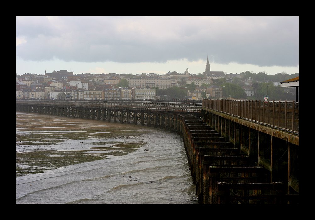
This is Ryde Pier, one of the main sights you'll definately see if you come to the Island as a foot passenger from Portsmouth. Due to the severe tides in this part of the world, the pier has to be long! nearly 700m long to be precise. A bit of background information from The Heritage Trail :

'Designed by John Kent of Southampton, the foundation stone of Ryde Pier was laid on 29th June 1813, the completed pier opening a year later on 26th July 1814. Overnight the perilous embarkation and disembarkation of the seafaring public had become a thing of the past. Originally built of timber, to a length of 1,740ft (527m), the pier was little more than a 12ft (3.6m) wide wooden jetty able to handle only relatively small sailing boats, but as the size of passenger vessels increased so did the pier. Ryde Pier was extended to a length of 2,040ft (618m) in 1824 and the pier-head was enlarged in 1827. A further extension in 1833 took the overall length to 2,250ft (681m), while the pier-head was again extended in 1842 and the late 1850s.'

View Satellite image of Ryde Pier @ Google Maps.
(looks like Google messed up a bit on this shot!)
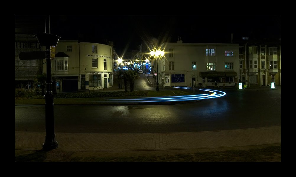
A little of the country, a little of the sea

On the Isle of Wight you get it all - countryside and then right next to it the sea. This is a view taken from the downs above Shanklin (on the way to Ventnor). In the distance you can once again see Culver Down (see previous post). We're facing north and you`ll come to mainland England if you continue across the sea in that direction (Selsey).

View Satellite image of this location @ Google Maps.

View Satellite image of Culver Down @ Google Maps.
You can clearly see the old Coastguard houses in this picture. I wonder how they got down to the sea.

Friday, July 14, 2006

Apply Tower

Apply Tower is a bit of a mystery. Located on the East beach of Ryde, far away from the crowded shopping streets this tower can be found on the way to Puckpool Park (a former fortification used during various wars). The details about the tower are sketchy at best, with rumours persisting that there is a network of old tunnels running from under it to the forts out in the Solent (you can see one of them just the right of the tower).

Currently its a seasonal shop of some kind, after being restored, and I think you can walk to the top of the tower when its open. Personally I`ve known about the tower for years, its been a constant fixture on the sea front and everybody uses it as a meeting point/focal point for events.

I managed to catch two jugglers in the picture in mid juggle - a bit of lucky timing!

View Satellite image of Apply Tower @ Google Maps.

Thursday, July 13, 2006

Quarr Abbey

Just on the outshirts of Ryde you can find Quarr Abbey. Its home to Benedictine Monks but you're welcome to drop in, have a cup of tea in the gardens, visit the chapel on a Sunday (when I took this shot if you notice the cars!) or just wander around looking at the architecture.

The original Quarr Abbey dates from 1132-1536, wheres the 'modern' Abbey dates from 1901-2004.Visit the Quarr Abbey web site for more information.

View Quarr Abbey @ Google Maps.
You can clearly see the whole Abbey and gardens in this picture.

Wednesday, July 12, 2006

Live in a Fairytale

One of the many thatched roof houses on the Island. They may look pretty but when you have to have the roof re-thatched once every five years it is an expensive way to live! The thatched houses date back to the 18th century. This one is in Ventnor.

Sunset aboard ship

This shot is taken from the top deck of one of the Fishbourne ferries you can take to the Island. Its mainly a car ferry but I feel, like many others, the high speed catamarans which take you there in 15 minutes, are just a little too quick. I think the trip needs to be savoured and the car ferry takes 45 minutes from Portsmouth.

You can enjoy the view, watch the ships in the Solent and generally relax, rather than be shunted on at one end and off at the other like a herd of sheep!

View Satellite image of Fishbourne @ Google Maps.
You can even see one of the car ferries docking in this picture!

Tuesday, July 11, 2006

The Countryside


A typical scene you might see on the Isle of Wight - beautiful lush pastures, trees and fields.

Saturday, July 08, 2006

Down at Joe's

This is Joe's, previously known as Joe Daflo's. Its down the main shopping street in Ryde, amongst the pubs and souvenir shops. Originally Joe Daflo's was started by Mark King of Level 42, but I heard he sold it on some time ago. Its created in the style of the US deep south - a jazz cafe kind of thing. There used to be live bands playing there, not sure if they do anymore.

Ryde is a funny place - the only major 'shops' in the town are estate agents, charity shops and souvenirs. They did say that Ryde was a dying town, losing many of its small family run stores after Somerfield (a large supermarket) was built there. I remember some time ago a decorating store closed and a sign was left in the window saying `we're leaving after 35 years in the same shop`.

You may have previously heard of Ryde in one of The Beatles most famous songs - 'Ticket to Ride (or Ryde)'. They're actually trying to get Paul to visit the Island as a tribute to the song :D

View Satellite image of Joe's and Union Street in Ryde @ Google Maps.

Friday, July 07, 2006

The pub at Fishbourne


One of the picturesque pubs you can find on the Island. This one (The Fishbourne Inn) is tucked just around the corner from the dock where the Portsmouth - Fishbourne car ferry arrives. A nice place to visit after the trip indeed! The pub was refurbished and extended in 2002 but I guess the original building dates way back.

View Satellite image of the Fishbourne Inn @ Google Maps.

Thursday, July 06, 2006

Visiting Ventnor: Summer palaces

I thought I would complete the Visiting Ventnor posts with another picture of some of the nice houses you can find down there. These were just tucked away on the side of a road that runs along the coast - you cant quite see the see from road level, but I`m sure you can from these houses top floors. I like the lush greenery and flowers in this shot.

Across the road from these houses is the local cricket club - I can imagine the owners settling down on their balcony to watch a match ;)

View Satellite image of this location @ Google Maps

Tuesday, July 04, 2006

At the beach

The Isle of Wight is famous for its sandy beaches and here is a prime example. This is a view from Shanklin facing towards Sandown on the East coast of the island. In the distance you can see Culver down which has amazing views from the top - there are some old coastguard houses right on the very top!

Also in the distance along the beach is Sandown pier - the only pier still standing along this stretch of the island after the storms of 1987 blew down Shanklin pier.

View Satellite image of this location @ Google Maps.

Visiting Ventnor: The Palm Garden

Ventnor Botanic Garden is host to many different plants and trees from around the world, mainly due to the location and temperate conditions that Ventnor brings. This is a good example of that, showing the beatifully designed 'Palm Garden'.

"The garden site was at one time a Royal National Hospital for diseases of the chest and for 80 years it was a major factor in Isle of Wight life at Ventnor. But with the discovery of an effective treatment for tuberculosis the hospital became redundant and soon deteriorated beyond repair. It was demolished in 1969."

There is a story that the gardens are haunted by the ghost of one of the nurses that was based at that hospital. You can see a picture of how the hospital looked here.

View Satellite image of Ventnor Botanic Garden @ Google Maps.

Sunday, July 02, 2006

Visiting Ventnor: Flowers in bloom


These are some of the typical houses you might find in Ventnor, at the far Southern most point of the Island. Its famous for being the hottest (near tropical) place on the Island, mainly due to overhanging hills that trap the hot air. You can find palm trees aplenty, a nice beach and some pretty houses. I`ll be posting a few pictures from there in the coming days.

View Satellite image of Ventnor @ Google maps.

Saturday, July 01, 2006

Visiting Ventnor: Bonchurch

This is the original chuch in Bonchurch, a small village just to the right of Ventnor. The church dates from 1080 (believe it or not). The local villagers look after the church and its open to the public most days during the summer.

I didn't know about this church before I came across it - its not well signposted, theres no cars allowed down the road that the church is located in and no traffic go past. Its kind of 'hanging' on the top of a cliff and I`m sorry to think that it might fall into the sea sometime in the future due to the erosion of the cliffs (the Island suffers from erosion badly).

View Satellite image of Bonchurch 'original' church.